
Welcome to Temecula, a city rich in geological wonders that showcase its fascinating rock formations and tell the story of its remarkable geological history. Temecula geology has long attracted the attention of geologists and rock hounds alike, making it an exciting adventure for anyone interested in exploring Southern California’s geological treasures.
The area boasts a variety of rock formations and geological features, including sedimentary rocks, igneous rocks, and metamorphic rocks. These formations hold a wealth of information about the region’s past, geological events, and the forces that have shaped the landscape over millions of years.
Key Takeaways:
- Temecula offers a variety of rockhounding locations, including Afton Canyon, Wiley’s Well, Palo Verde Mountains, Chambless, and Turtle Mountain.
- It is important to research and obtain permission before visiting these sites, and to follow the rockhounding laws and regulations for each location.
- Respecting private property and preserving the natural resources of the area is crucial.
Exploring the Forces of Erosion and Down-Cutting
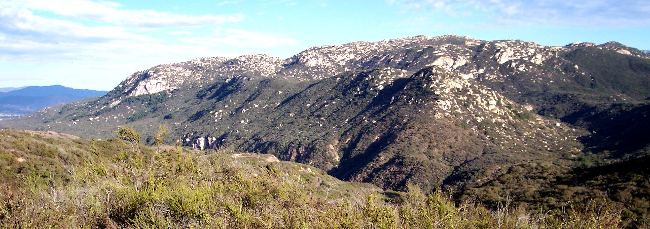
Geologists have long been captivated by the forces of erosion and down-cutting that have sculpted Temecula’s stunning geological features, conducting detailed surveys to unravel the secrets of this remarkable landscape. One example of this is the Santa Margarita River in California, which has narrow canyon walls that are inclined at steep angles due to down-cutting that occurred after the formation of the surrounding terrain. Geochronological data suggests that the river likely began to cut into the landscape during a drop in sea level thousands of years ago.
The Temecula Canyon in Southern California is another example of erosion and down-cutting. The canyon was formed millions of years ago when sediments accumulated on an ocean floor, eventually transforming into shale and sandstone. Subsequent processes, such as volcanic activity and uplift, led to the formation of the present-day canyon.
Rockhounding is a popular activity in Southern California, with various locations offering opportunities to collect minerals and fossils. Some notable sites include Afton Canyon, Wiley’s Well, Palo Verde Mountains, Chambless, and Turtle Mountain. These locations offer a range of minerals such as agates, jaspers, fire agate, thundereggs, hematite, magnetite, and trilobite fossils. It is important to follow the laws and regulations for each collection site and obtain permission if necessary.
Unveiling the Ancient Temecula Canyon
Immerse yourself in the geological wonders of Temecula Valley as we unveil the fascinating history of the ancient Temecula Canyon, a testament to the region’s geological richness.
The canyon began around 225 million years ago when the region was underwater, accumulating mud and sand that eventually transformed into shale and sandstone. Subduction occurred about 150 million years ago, leading to the formation of volcanoes and the eruption of molten rock. Over the next 75 million years, the molten rock metamorphosed some of the rocks in the canyon, leading to the development of the Woodson Mountain granodiorites.
For the next 70 million years, erosion occurred, creating a flat coastal plain. Approximately 5.5 million years ago, the area became geologically active again as the San Andreas Fault formed and uplifted the Santa Ana Mountains. The Santa Margarita River, which flows through Temecula Canyon, is antecedent, meaning it existed before the mountain range and carved its path through it.
Today, Temecula Canyon offers an opportunity for rockhounding, with minerals such as agates, jaspers, thundereggs, fire agate, and more found in various canyon locations. The canyon is part of the Santa Margarita Ecological Reserve, and access is limited to pre-arranged tours.
Exciting Geology in Temecula Valley
The formation of the ancient Temecula Canyon is just one of the exciting geological features found in Temecula Valley. The region is home to diverse rock formations, including the Santiago Peak volcanics, resulting from subduction and volcanic activity. Additionally, the dynamic cycle of uplift and erosion has shaped the region over millions of years, creating unique geological landmarks worth exploring.
Are you planning to explore the geology of Temecula Valley? Take advantage of the opportunity to visit the ancient Temecula Canyon and immerse yourself in the fascinating geological history of the region.
From Sediments to Shale and Sandstone
Through accumulation and transformation, the sediments of Temecula gradually solidified into magnificent layers of shale and sandstone, marking pivotal moments in its geological history. Over millions of years, the Santa Margarita River and Temecula Canyon have undergone significant changes shaped by the forces of nature. The intense heat and pressure subjected to sedimentary deposits led to their transformation into shale and sandstone.
Explorers and rockhounding enthusiasts can find a variety of minerals in different locations in Southern California, including Temecula. The Afton Canyon, Wiley’s Well, Palo Verde Mountains, Chambless, and Turtle Mountain are popular rockhounding destinations, where you can collect agates, jaspers, geodes, trilobite fossils, and more.
While rockhounding is a popular activity, it is important to remember that certain laws and regulations protect collecting sites, and it is important to obtain permission before visiting these areas. Additionally, it is crucial to practice ethical rockhounding by not damaging natural formations, respecting private property, and only collecting minerals that are legally allowed.
“The geological history of Temecula and other regions in Southern California is fascinating, and the study of sedimentary rocks helps us to understand the changes that took place over millions of years. Observing and collecting rocks and minerals provides not only an enriching educational experience but also a connection to the natural world around us,” said a member of the Temecula Geological Society.
Unearthing the Legacy of Subduction and Volcanic Activity
Journey back in time to an era marked by subduction and volcanic activity as we uncover the remarkable geological formations of Temecula and discover how occasional earthquakes have shaped the landscape.
The Santa Margarita River and Temecula Canyon provide valuable geological information about the processes that have shaped the region. The Santa Margarita River has experienced significant downcutting, likely during a drop in sea level around 24,000 to 18,000 years ago.
The canyon contains paralithic materials consisting of corestones and saprock, indicating the presence of subduction and volcanic activity in the past. The Temecula Canyon was formed about 225 million years ago when the region was underwater, accumulating mud and sand that eventually transformed into shale and sandstone. Around 150 million years ago, subduction occurred, forming volcanoes and erupting material that is now the Santiago Peak volcanics. The subduction continued for millions of years, creating molten rock and a string of volcanoes, until it shifted to a more shallow angle, causing the volcanic activity to cease.
The uplift of the Santa Ana Mountains led to the formation of the Santa Margarita River, which cut across the high mountain range. The area has also been a hotspot for rockhounding enthusiasts, with locations like Afton Canyon, Wiley’s Well, Palo Verde Mountains, Chambless, and Turtle Mountain offering opportunities to find agates, jaspers, thundereggs, fire agate, and trilobites.
The occasional earthquakes experienced in Temecula are a result of the region’s unique geological history. These natural phenomena provide a fascinating insight into the ongoing dynamic cycle of uplift and erosion that continues to shape the landscape.
The Dynamic Cycle of Uplift and Erosion
Throughout millions of years, Temecula has undergone a mesmerizing cycle of uplift and erosion, inviting us to explore its geological mysteries and embrace the fascinating world of geoscience. This area has experienced a dynamic cycle of earth movements that have shaped and reshaped the landscape. Geology in Temecula offers an opportunity to witness this cycle in action and learn about the processes that have created the land formations we see today.
Temecula geology exploration has revealed that this cycle has particularly affected the Santa Margarita River and Temecula Canyon area. The river’s down-cutting likely began around 24,000 to 18,000 years ago during a drop in sea level. This post-dated the development of a broad undulating terrain, indicating that the river’s down-cutting has been an enduring process, shaping the landscape over an extended period.
The geology in Temecula also has a rich history that dates back millions of years. The area was once underwater, covered with mud and sand deposits. As the continents began to break apart, the North American nucleus started to override the oceanic crust, transforming the sedimentary deposits into shale and sandstone. Subduction of the oceanic crust caused volcanic activity, leading to the formation of volcanoes and the eruption of molten rock. Over millions of years, erosion wore away the volcanic mountains and reshaped the landscape.
Rockhounding enthusiasts can explore various locations in Southern California to witness the effects of uplift and erosion. These locations showcase the diverse geological formations that have been shaped over time. For example, Afton Canyon, Wiley’s Well, Palo Verde Mountains, Chambless, and Turtle Mountain offer opportunities to explore the region’s rich mineral deposits and discover interesting fossils.
Overall, Temecula’s dynamic cycle of uplift and erosion has created a unique and diverse geological landscape, offering a glimpse into the fascinating world of geoscience. Understanding the geological processes that have shaped the area’s formations provides a greater appreciation for the natural wonders around us.
The Birth of the Santa Ana Mountains
Let’s turn our attention to the birth of the iconic Santa Ana Mountains, a testament to the geological landmarks that define Temecula and the occasional rumblings of earthquakes that captivate residents and visitors.
The Santa Ana Mountains, located in Southern California, have a fascinating geological history that dates back over 200 million years. The mountains were formed due to the collision of continental plates, which caused sediment to accumulate on the ocean floor. Over time, these sediments transformed into shale and sandstone.
Further changes to the landscape were made through the subduction of oceanic crust and volcanic activity. The molten rock from the volcanoes metamorphosed the sedimentary rocks, creating contorted layers. Eventually, about 75 million years ago, the subduction angle changed, leading to the solidification of molten rock and the formation of granitic rocks, known as the Woodson Mountain granodiorites.
Over millions of years, erosion shaped the Santa Ana Mountains into their current form. The Santa Margarita River played a significant role in cutting through the mountains and forming the unique geological landmarks that we see today. The birth of the Santa Ana Mountains is a result of complex geological processes, and they provide a unique natural resource that should be preserved for generations to come.
Rockhounding: Exploring Temecula’s Diverse Geology
Embark on an exciting rockhounding adventure as we uncover hidden gems in Temecula’s diverse geology, presenting fascinating opportunities for both experts and enthusiasts alike. Rockhounding is a popular activity in Southern California, and Temecula is known for offering a variety of options for rock enthusiasts.
Although not in Temecula, Afton Canyon is a notable rock-hounding location, often called the “Grand Canyon of the Mojave.” Here you can find agates, jaspers, fluorite deposits, and other minerals. Please go to Wiley’s Well, known for its thundereggs, fire agate, rhyolite, jasper, and colorful quartz crystals. If you’re in search of Hauser Geode Beds, visit Palo Verde Mountains, where you can find geodes, fire agate, petrified wood, and more.
Chambless is another great location, and trilobite enthusiasts flock to this area. Here you can find magnetite, hematite, and other minerals. Lastly, Turtle Mountain offers beautiful chalcedony, agate, jaspers, opalites, and various wildlife species.
While engaging in rockhounding, it is essential to know the laws regulations, and obtain permission for collecting at each site. With so many diverse rockhounding sites in Temecula, there’s no limit to the fascinating geology waiting to be discovered. Plan your rockhounding expedition today and uncover hidden gems in this mesmerizing region.
Conclusion
As we conclude our friendly local guide to uncovering Temecula geology, we hope you’ve gained a deeper appreciation for the region’s geological wonders and are inspired to explore the fascinating world of geology further. If you’re a passionate rockhound, Southern California offers a multitude of rockhounding locations for you to discover and explore.
Southern California’s diverse geological formations make it a treasure trove for rock hounds and a must-visit destination for rock-hounding enthusiasts. So, grab your rock hammer, put on your hiking shoes, and start exploring the fascinating world of geology!
FAQ
Q: How has the Santa Margarita River and Los Flores Creek been shaped?
A: They have been shaped by erosion and down-cutting over thousands of years.
Q: When did the Santa Margarita River likely begin down-cutting?
A: It likely began down-cutting during a drop in sea level around 24,000 to 18,000 years ago.
Q: When did the Temecula Canyon form?
A: The Temecula Canyon formed about 225 million years ago when the region was submerged under the ocean.
Q: How did sediments in the Temecula Canyon transform?
A: Sediments accumulated and eventually transformed into shale and sandstone due to heat and pressure.
Q: When did subduction and volcanic activity occur?
A: Subduction and volcanic activity occurred around 150 million years ago, leading to the formation of the Santiago Peak volcanics.
Q: What happened in the area for the next 70 million years?
A: The area underwent uplift and erosion for the next 70 million years.
Q: When did the Santa Ana Mountains begin to form?
A: Due to tectonic movement, the Santa Ana Mountains began to form 5.5 million years ago.
Q: What type of river is the Santa Margarita River?
A: The Santa Margarita River is antecedent, existing before the surrounding mountain range.
Q: What are some recommended rockhounding locations in Southern California?
A: Afton Canyon, Wiley’s Well, Palo Verde Mountains, Chambless, and Turtle Mountain are recommended rock-hounding locations in Southern California.DOn’t forget near Temecula you can go to Pala of Rice Cayon road to hunt for gems.
Source Links
- https://tchester.org/fb/geology/temecula_canyon.html
- https://rockseeker.com/rockhounding-in-southern-california/
- https://fsp.sdsu.edu/geology/
- https://temeculaca.gov/CivicAlerts.aspx?AID=1217
- https://gotbooks.miracosta.edu/fieldtrips/calavera_hills_volcano/index.html
- https://temeculaca.gov/150/History-of-Temecula
- https://www.osti.gov/servlets/purl/903323
- https://www.washington.edu/news/2011/10/19/fiery-volcano-offers-geologic-glimpse-into-land-that-time-forgot-with-video/
- https://www.usgs.gov/special-topics/subduction-zone-science/science/introduction-subduction-zones-amazing-events
- https://www.geo.fu-berlin.de/en/v/geolearning/mountain_building/weathering/Erosion7/index.html
- https://www.nps.gov/yose/learn/nature/geology.htm
- https://thesis.library.caltech.edu/821
- https://en.wikipedia.org/wiki/Santa_Ana_Mountains
- https://rockhoundresource.com/california-rockhounding-location-guide/
- https://discoveringhiddengems.com/rockhounding-hotspots-southern-california/
- https://ca.water.usgs.gov/projects/temecula/overview/background.html